Asian Ethnicity Quiz: Drawing the Border Before the Answer
The word Asian covers 56 to 85 catalogue entries depending on where the line is drawn, and almost none of them is named after a country.
The word arrives with a border
A search for an Asian ethnicity quiz usually opens with a face and five buttons. China, Japan, Korea, Vietnam, India. The buttons look like a neutral description of a continent. They are a description of whichever administrative form the person who wrote the quiz filled in last, and that form has been redrawn twice within living memory, in 1997 and again in 2024.
The United States definition, fixed in the 1997 revision of Statistical Policy Directive 15, covers origins in the Far East, Southeast Asia and the Indian subcontinent, then lists Cambodia, China, India, Japan, Korea, Malaysia, Pakistan, the Philippine Islands, Thailand and Vietnam. Iran, Iraq, Israel and Turkey are absent from that list, because the same directive files them under White. The 2024 revision pulled Middle Eastern and North African origins into a category of their own, so a family from Tehran changed boxes without leaving the city.
British forms split the continent differently. The 2011 census for England and Wales keeps Indian, Pakistani, Bangladeshi and Chinese inside one Asian group, while ordinary British speech applies the word mainly to South Asian people. A quiz written in Manchester and a quiz written in Ohio are asking about different sets of people with the same three words, and neither quiz states which set it means.
Where this catalogue draws the line
This site holds 209 entries, each filed under one of 22 regional labels. Counting the ones a demographer would call Asian depends on how far west and north the line runs. East Asia holds 11, South Asia 20, Southeast Asia 17 and Central Asia 8, which makes 56 in the narrow reading. That figure is the one most quizzes have in mind when they offer a short row of national buttons.
Widen the line and the number moves. Adding the Middle East gives 65, adding Siberia gives 73, adding the Caucasus gives 75. Fold in North Africa the way a MENA category does and the total reaches 85, more than a third of the catalogue. A quiz offering five buttons has already settled the boundary question on the reader's behalf, and its answer is not the catalogue's answer.
The gap between those two numbers is where most of the confusion in these games lives. A player who is told the answer was Japanese has not been told which of eleven East Asian rows the composite came closest to, or whether the nearest row was Japanese at all. The forced choice supplies certainty that the underlying record never had.
Fifty-six is not a count of peoples
The imbalance inside those totals has an administrative history rather than a biological one. South Asia carries 20 entries against East Asia's 11, and the South Asian titles read like a survey schedule: Vedda, Toda, Malabarese, Sinhalesid, Karnatid, Keralid, Kolid, Malid, North and South Gondid. B. S. Guha's 1931 ethnography for the Indian census sorted the subcontinent into six elements, and later cataloguers subdivided that scaffold rather than replacing it.
China's rows descend from a different exercise. Liu C. H.'s 1937 paper, A tentative classification of the races of China, printed in Zeitschrift für Rassenkunde, appears in the source list of both Huanghoid and Changkiangid, next to Eickstedt's 1934 handbook. That journal stopped publishing in the 1940s and no later survey replaced the rows it carried, so the Chinese entries record where a 1930s expedition could bring calipers and a camera, and the count of eleven follows that itinerary rather than a census.
Named after rivers, provinces, and islands
The East Asian names read as a gazetteer. Huanghoid takes the Huang Ho, the Yellow River, and its text places the type among loess and millet farmers in Liaoning, Kirin, Heilungkiang and Jehol. Changkiangid takes the Chang Kiang, the Yangtze, and ties the type to rice farming in Kiangsu, Chekiang, Anhuei and Szechuan. Chukiangid takes the Chu Khang, the West River, and ties it to fishing and gathering in the subtropical forests of Guangdong and Fukien. A watercourse rather than a state is the anchor in all three cases, which is what survey work along river valleys produces: the samples travelled by boat and cart, and the names recorded the route.
Others are domains and islands. Chikuzen is an old province now inside Fukuoka Prefecture, Choshiu the Choshu domain, now Yamaguchi. Ishikawa is a region of Honshu, Aoshima an island, Kham the eastern Tibetan plateau. Yakonin is the exception that proves the rule, because its name comes from yakunin, the Japanese word for a bureaucrat, rather than from a place. The rest follow the convention of naming a row after something a surveyor could point to on a map, which is why the catalogue reads as a gazetteer while the quiz reads as a list of passports.
The spelling dates the layer as well. Kirin, Heilungkiang, Kiangsu, Chekiang and Szechuan are Wade-Giles, displaced by pinyin in the 1950s and adopted by the ISO only in 1982. The names were fixed before the current provincial map was drawn, and no later editor went back to revise them, which is why a page describing twenty-first-century Liaoning still spells the province Kirin.
Two entries 306 kilometres apart
Aoshima and Satsuma are both filed under East Asia and both describe Japan. Aoshima is the older layer, linked to Jomon remains, short-bodied, mesoskelic, dolicho- to mesocephalic, large-headed, with a prominent nose. Satsuma is the reverse profile, described as the most numerous element in the country, brachycephalic and hypsicranic, along the southern coasts of Kagoshima, Shikoku and Honshu. Their coordinates sit 306 kilometres apart, which is less than London to Paris.
One entry sits near the dolichocephalic end of the cranial index and the other near the brachycephalic end, and a quiz with a single Japan button averages them into a shape that neither describes. The average is not false. It is a centre, and a centre summarises a distribution well enough as long as nobody is asked to recognise it as a person.
What the average face holds
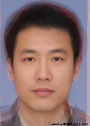
The answer key in these games is a composite. Photographs are aligned on the pupils, averaged pixel by pixel, and printed as one face per option. Aligned averaging removes pose and lighting and leaves a centre of the sample, which is why composites look calm and slightly generic. It also means that the answer to any round is a distance to a centroid, not an identification.
Movement since 1950 changed the samples without moving a border. China recorded roughly 297 million migrant workers in 2023, a figure close to the entire population of the United States, and most of them work in cities whose composites were assembled from provincial photographs. A face photographed in Shenzhen can sit closer to a Hunan or Sichuan centroid than to the Guangdong one the button promises, and the quiz will record that as a miss.
What an answer can honestly be
A quiz built on this record can return a ranked shortlist, the distance to each centroid, and the name of the nearest entry. It cannot return an ethnicity, because the unit here is a documented appearance pattern with a historical distribution, not a living person's origin. Those are different objects, and no increase in resolution converts one into the other.
Livingstone argued in 1962 that there are no races, only clines: a trait's frequency shifts gradually across geography, and every border drawn through a gradient is a decision rather than a find. Lewontin's 1972 count, that roughly 85 percent of human genetic variation falls inside any single population, makes the same point from the other direction. A face quiz can be honest about its buttons. It cannot claim the buttons were discovered.
Frequently Asked Questions
- Does an Asian ethnicity quiz cover the whole of Asia?
- Rarely. The 1997 United States definition limits Asian to the Far East, Southeast Asia and the Indian subcontinent, and files Iran, Iraq, Israel and Turkey under White. This catalogue holds 56 entries in that narrow reading, 75 once the Middle East, Siberia and the Caucasus are counted, and 85 with North Africa included. Most quizzes offer four to six buttons, so the answer set reflects a choice about the boundary rather than a summary of the record.
- Why are there more South Asian entries than East Asian ones?
- Because the surveys behind them were separate projects with different budgets and different reach. B. S. Guha's 1931 census ethnography divided the Indian subcontinent into six elements, and later cataloguers kept splitting them, which produced 20 rows. China's rows descend from Liu C. H.'s 1937 classification and the expeditions that could reach Manchuria and the Yangtze valley, producing 11. The totals record how finely researchers subdivided, not how much variation exists.
- Is Asian a phenotype in this catalogue?
- No. Asian is a regional label applied to entries rather than an entry itself, and the 209 rows are sorted under 22 such labels. The entries carry names taken from rivers, provinces, islands and occasionally language families, so Huanghoid is the entry and East Asia is only its filing cabinet. Treating the filing label as the trait is the most common error in reading the output of a face quiz.
Related Phenotypes
Faces from the encyclopedia that appear in this article. Open any entry for its full description, distribution, and references.
Huanghoid
East Asia
North Sinid type, named after the Huang Ho (Yellow) river in Northern China. Developed from loess and millet farmers. Usually regarded as th...
Changkiangid
East Asia
Sinid subtype, named after the Chang Kiang (Yangtze) river in Central China. Today the most populous human variety in the world. Developed f...
Aoshima
East Asia
Ainuid proper, the most ancient type of Japan. Resembles Paleolithic Japanese populations like the Jomon people. Probably a relict of an old...
Test what you learned
Put your eye for regional faces to work in the daily quiz — a composite face, a world map, and your best guess.