A Daily Geography Game Runs Out of Countries in 193 Days
One answer a day needs 365 a year, and the world supplies fewer sovereign states than that, which is why map games are built around modes rather than answers.
One puzzle a day is a supply problem
A daily geography game looks like a software project and behaves like a publishing schedule. The code is written once. The answers have to be supplied forever, one per day, in an order nobody can predict and nobody can call unfair. Do the arithmetic before anything else. Three hundred and sixty-five answers a year is the baseline requirement, and geography is not unlimited in the way that vocabulary is. The United Nations has 193 member states. The ISO 3166-1 standard assigns 249 two-letter codes once territories and dependencies are counted. Those are the two lists most country quizzes draw from, and neither one lasts a year.
That gap explains a lot of the genre's behaviour. English supplies roughly twelve thousand five-letter words, and Wordle's answer list was cut to 2,315 of them, which is six years and four months of daily play from a single curated list. Geography supplies 195 sovereign states at most, or 249 codes if you widen the definition. A map game does not have a curation problem. It has a shortage, and most of the genre's design decisions are responses to it.
The answer list is edited, not found
Wordle's list is the best-documented example of what an answer key is. Josh Wardle started from about twelve thousand five-letter words and had his partner Palak Shah go through them flagging the ones she recognised, which produced 2,315 answers against a separate guess list of 10,657. The filter was not a dictionary rule. It was one person's judgement about which words a general player would know, applied by hand, and the game's sense of fairness rests on that judgement rather than on any property of English.
The New York Times edited the list again after buying the game in January 2022, removing words for two different reasons: sensitivity, which took out slave, lynch and wench, and obscurity, which took out pupal and agora. Note what that means for a daily puzzle. Every removal is a permanent decision taken against a schedule that is partly published already, and no puzzle that has run can be recalled. A geography key works the same way, except that its entries are supplied by governments rather than by a dictionary, and governments revise without asking.
The key goes stale on its own
Country names change and the changes are recorded. The United Nations Statistical Yearbook carries an annex of country and area name changes, and since 31 July 2008 it lists fifteen: South Sudan and Sudan in 2011, Curacao, Sint Maarten and Bonaire in 2010, the Netherlands in 2023, Turkiye in 2022, North Macedonia in 2019, Eswatini in 2018, Czechia in 2016, Cabo Verde and the State of Palestine in 2013, Libya in 2011, Bolivia in 2009 and the Republic of Moldova in 2008.
Turkiye is the cleanest case for anyone building a game. The change arrived in a letter from the Turkish foreign minister to the Secretary-General, and the United Nations treated it as effective on receipt in June 2022. Nothing moved. No border shifted, no population changed, and the map did not redraw itself, yet every answer key written before that summer now holds a spelling the source of record has abandoned. A game built in 2015 and left untouched is wrong on at least six of those fifteen entries, and wrong in the way players notice: on the day they type the name they learned at school.
Even the landforms move
Physical geography looks like the stable layer and is not. The Aral Sea covered about 68,000 square kilometres in 1960 and was the fourth largest lake in the world. By 2010 its surface had fallen 88 percent and its volume 92 percent, and in August 2014 satellite imagery showed the eastern basin completely dry for the first time in modern history. The ground is now called the Aralkum Desert and lifts an estimated 75 million tonnes of dust a year. The name outlived the water by a few decades, which is longer than most names get.
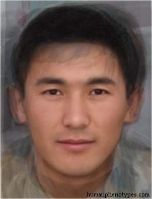
This matters for a catalogue built on place names, because a key made of names inherits the fate of the places. Mountain Aralid is native to the Tian Shan of Kyrgyzstan and western China, conventionally grouped with Aralid, and the Aral in both names refers to a sea that is now mostly desert. Ishikawa is named for a region of Honshu and still describes a population in the northern middle of that island, so its name has held. Bering Sea is the western Eskimid variety recorded along the strait and on St. Lawrence Island, and its name now also marks a border and a calendar line, so that the same water sits on two dates at once. Canarid is named for the Canary Islands and records a historical distribution among the Guanches of Gomera, Tenerife and Gran Canaria, with a note that the islands are heavily mixed today.
Three levers when the list runs short
Operators have three ways to make a short list last, and each one changes what the game is testing. The first is to divide the answers, turning a country into a province and a province into a coordinate. The second is to ask about the same answer differently. The third is to publish a cycle and restart it, accepting that a player who stays for two years will see repeats and will notice them.
- Divide: a country becomes a province, a province becomes a point, and an unlabelled street panorama has an unbounded answer space because any coordinate on Earth is a valid guess.
- Re-ask: 193 states put to four questions, a flag, an outline, a capital and a chain of neighbours, is 772 daily puzzles, a little over two years of play.
- Cycle: restart the list on a fixed period and let the archive become the consolation for anyone who misses a day.
- Cap the surface: the catalogue behind this site holds 209 entries, which is 209 days at one a day, less than a single year.
The operator's year
Once the supply is understood, the daily format looks less like a product and more like a calendar with a proof step attached. Someone has to choose the next 365 answers, check each against a source, decide what happens when two sources disagree, and keep the queue ahead of publication by enough margin that a correction is still possible. Code is reviewed before it ships. A puzzle is checked before it ships and then cannot be recalled, which makes the checking the expensive part.
There is also a spoiler problem built into the format. The answer has to reach the player's browser before the player commits, so a determined player can read it, and a shared grid can leak the shape of an answer without ever stating it. That pressure is why daily games converge on the same conventions: one puzzle for everyone, a reset instant fixed by the operator rather than by the local clock, and a share string that reports the pattern of hits instead of the answer.
Territory is not population
The last thing an answer key commits to is a claim about what a country is. A geography game's unit is a bordered territory with a name and a date, and the people inside it move, so the map in a daily game is always slightly out of date in a way no update can fix. The more honest versions of the genre therefore ask you to place a place rather than to characterise a population. Two questions, two keys, and only one of them can be checked against a coordinate.
This site's daily quiz sits on the other side of that line on purpose. Its answers are catalogue entries with a region, a named author, a year and a coordinate, drawn from records describing appearance patterns roughly fifteen hundred years old. A round asks you to match a composite face to a documented distribution, which is a task with a checkable answer and no claim about anyone living. The 209-entry limit is not a defect waiting to be fixed by adding rows. It is the honest size of the key.
Frequently Asked Questions
- How many countries does a daily geography game need?
- At least 365 to run a year without repeats, and no standard list supplies that many. The United Nations has 193 member states, and ISO 3166-1 assigns 249 two-letter codes once territories and dependencies are included, so a country-per-day game exhausts either list inside a year. Word games face no such limit, which is why Wordle's curated list of 2,315 answers covers six years and four months. A map game's constraint is supply, not code.
- Why do country names in quizzes go out of date?
- Because governments rename states and the record follows. The United Nations Statistical Yearbook lists fifteen country and area name changes since July 2008, including Eswatini in 2018, North Macedonia in 2019 and Turkiye in 2022. The Turkish change arrived as a letter to the Secretary-General and took effect on receipt, with no border moving. A quiz written before it still teaches the older spelling, and a daily puzzle that has already run cannot be corrected.
- Do place names in a phenotype catalogue stay accurate?
- Rarely for long. Names drawn from landforms outlive the landforms by only a few decades: the Aral Sea lost 88 percent of its surface and 92 percent of its volume between 1960 and 2010, and its eastern basin dried completely in 2014. Entries such as Mountain Aralid still carry the name. Others, like Canarid from the Canary Islands, describe distributions the record itself notes are heavily mixed today. The name marks where a type was described, not a population that persists unchanged.
Related Phenotypes
Faces from the encyclopedia that appear in this article. Open any entry for its full description, distribution, and references.
Mountain Aralid
Central Asia
Tungid variety, weakly influenced by Turanid. Usually united with Aralid, but more Mongoloid. Native to the Tian Shan mountains of Kyrgyzsta...
Ishikawa
East Asia
Special Japanese type, influenced by ancient regional elements. Named after the Ishikawa region of Honshu. Probably represents admixed varia...
Canarid
Southern Europe
Maghrebi type with similarities to Cromagnids and North Europeans - probably in part a result of convergent evolution of pre-Neolithic North...
Bering Sea
Siberia
Western Eskimid variety common in Alaska and along the Bering Strait, esp. St. Lawrence Island. The result of a relatively late migration to...
Test what you learned
Put your eye for regional faces to work in the daily quiz — a composite face, a world map, and your best guess.