Average Face of Korea: The Record Is Pinned North of the DMZ
The catalogue holds one entry for the whole peninsula, and its map pin sits at 45.8 degrees north in Manchuria, about 860 km above the demilitarized zone.
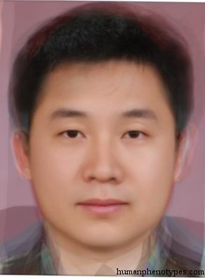
Four steps and one hard question
Every national composite face is built the same way. Someone defines the group, collects frontal photographs of people in it, registers a fixed set of landmarks on each frame, and averages the pixel values. The arithmetic is the easy part. The hard part is the first step, because a group has to be drawn before it can be averaged, and drawing it is a decision rather than a measurement. For a state with one language, one passport and one set of identity-photo regulations, the sample nearly defines itself. The Korean peninsula is the case where it does not, and the reasons are political, archival and demographic at once.
The photographic requirement is what makes archives matter more than populations. A composite needs every face at the same angle, the same scale and roughly the same expression, so the practical source is identity photography, the one genre shot to a written standard and kept in bulk. That has a consequence worth stating plainly: a national average tends to inherit a country's photo regulations more than the range of faces inside it. Where the archive is thin, closed, or unevenly kept, the composite is not a portrait of a population. It is a portrait of whoever was photographed, in the format the photographer was required to use.
One entry covers the whole peninsula
The catalogue behind this site does not carry an entry called Korea. It carries Manchu-Korean, a North Sinid subtype described as significantly influenced by Tungid and typified by Manchu and Koreans. The stated distribution runs from Manchuria and North China through Central and North Korea, with a Japanese subvariety around Kyoto and western Honshu, and the Choshiu type sometimes folded in. Read that list closely and a boundary appears that has nothing to do with the demilitarized zone. The description names the centre and the north of the peninsula and stops there. A reader looking for the southern half in this record will not find it named, not because the south differs but because the observers who built the entry were working north of it.
That is a statement about the literature, not about people. The typological handbooks were assembled by travelling observers and anatomists who measured where institutions let them measure, and the resulting grid is dense where expeditions went and thin where they did not. A record that names Central and North Korea while leaving the south unnamed is reporting where the measuring happened. It says nothing about whether the peninsula's southern half lacks the traits in the description, and it should not be read as a claim about anyone alive.
The pin sits at Harbin
Each entry also carries a coordinate, and this is where the record gets more interesting. Manchu-Korean is pinned at 45.76 degrees north, 126.63 east, which is Harbin, in Heilongjiang: about 860 kilometres north of the demilitarized zone and roughly 900 from Seoul. The peninsula itself runs from about 33 to 43 degrees north, so the pin sits outside the entire landmass the entry describes, in the Manchurian core of its own distribution list.
The pin is not a mistake and it is not a centroid. It is where the entry's name points, and the same convention shows up elsewhere. Huanghoid is pinned at 35.08 degrees north, 97.94 east, high on the Yellow River in Qinghai, while the provinces its description calls typical are Liaoning, Kirin, Heilungkiang and Jehol, some two thousand kilometres to the east. The coordinate follows the referent inside the name, in this case the river's upper course, rather than the provinces the text says are typical. Anyone reading a map built from these pins is looking at a map of where the names come from. That makes it a good map of intellectual history and a poor map of settlement.
The neighbours are continental
Part of the reason the peninsula gets a single cell is that everything around it is drawn at continental scale. Four entries frame the region, and each covers an area many times the size of Korea. The result is that the peninsula reads as a narrow strip where several large descriptions meet, rather than as a region the literature subdivided. The four are worth listing, because the geography of the list explains the geography of the map.
- Gobid, a Tungid variety of the Central Asian deserts and steppes, most typical among Buryat, Mongolians and Tuvins, and carried west to the Caspian by Kalmyks in the seventeenth century.
- Huanghoid, named for the Yellow River, whose described core includes the Manchurian provinces of Liaoning, Kirin and Heilungkiang.
- Changkiangid, named for the Yangtze and described as today the most populous human variety in the world.
- Manchu-Korean itself, straddling the Yalu and the Tumen and reaching north into the Amur valley.
Which Korea was photographed
Return to the composite and the sampling question has a blunt answer. North Korea holds roughly 26 million people and publishes no open portrait archive, so it contributes almost nothing to any average face of Korea that exists online. South Korea holds a registered population of 51.2 million and has the identity-photo infrastructure, so the composite is overwhelmingly southern. Whatever the label says, the arithmetic is a South Korean average carrying a northern inheritance in its name.
The southern archive is changing faster than the label. Foreign residents in South Korea reached 2,650,783 at the end of 2024, or 5.17 percent of a registered population of 51,217,211, up from roughly 490,000 and one percent in 2000. Chinese nationals formed the largest group at 958,959, a figure that includes a large number of ethnic Koreans from China. A composite built from recent identity photographs is therefore averaging a population the historical entry was never describing, and doing it with a sample that includes faces the nineteenth-century observers had no way to record.
Three populations called Korean
The mismatch has a documented history and it runs in both directions. In September and October 1937 the NKVD moved nearly 172,000 Soviet Koreans from the Russian Far East to Kazakhstan and Uzbekistan under a decree numbered 1428-326, using 124 trains over 6,400 kilometres, and estimates of deaths during and after the transfer run from 16,500 to 50,000. Their descendants are still in Central Asia, four generations on, and call themselves Koryo-saram.
A second population sits across the Tumen. China's 2020 census counted 1,702,479 ethnic Koreans, down 128,000 from 1,830,929 a decade earlier, with roughly 700,000 of them living in South Korea. In Yanbian, the autonomous prefecture established in 1952, the Korean share fell from 70.5 percent at founding to 30.8 percent, a decline that carries legal weight because China's rules for autonomous prefectures turn on the thirty percent line. Three populations, one word, three different photographic histories: a divided peninsula, a Chinese prefecture, and a Central Asian community that has been where it is for eighty-nine years.
What the composite can be asked
A composite can be asked what a set of photographs averages to. It cannot be asked what Korea looks like, because that question smuggles in a definition four different populations would answer differently, and because the historical entry it descends from was drawn by observers working north of the peninsula. The honest version of the question is narrower and still useful: given this archive, this date and this registration standard, what is the mean face of the sample?
The narrowing is not a dodge. It is what makes the picture checkable. A composite that states its sample can be rebuilt and argued with; one that claims a nation cannot be tested at all. The same rule governs the catalogue entries published here. They describe appearance patterns recorded in named places at a named time, roughly fifteen hundred years back, and they do not name individuals or assign anyone living to a category. The pin at Harbin is a fact about a book, and a fact about a book is not a fact about a person.
Frequently Asked Questions
- Why does the average face of Korea look southern?
- Because the archive is southern. North Korea holds about 26 million people and publishes no open portrait collection, so it contributes almost nothing to any composite available online. South Korea has 51.2 million registered residents and a standardised identity-photo system, which is what a composite needs as input. The label covers the peninsula; the arithmetic covers the state that photographs its residents in a consistent format. That is a fact about archives, not about how anyone looks.
- Where is the Manchu-Korean entry placed on the map?
- At 45.76 degrees north, 126.63 east, which is Harbin in Heilongjiang, roughly 860 kilometres above the demilitarized zone. The peninsula runs from about 33 to 43 degrees north, so the pin falls outside it. The coordinate marks where the entry's name points rather than the centre of the described distribution, a convention visible elsewhere in the catalogue: Huanghoid is pinned high on the Yellow River in Qinghai while its described core lies two thousand kilometres east.
- Can a composite face or a catalogue entry identify a person?
- No. A composite is an average of a stated sample, and a catalogue entry describes a pattern recorded in named places at a named time, roughly fifteen hundred years ago. Neither is a test. The entry for the peninsula records appearance tendencies in a historical sample and says nothing about which individual belongs to it, because clinal variation means the boundaries run through populations rather than around them. Any claim that a face reveals a nationality or an ancestry is making a different assertion, and the record published here does not support it.
Related Phenotypes
Faces from the encyclopedia that appear in this article. Open any entry for its full description, distribution, and references.
Manchu-Korean
East Asia
North Sinid subtype, significantly influenced by Tungid. Typified by Manchu and Koreans. Most common in Manchuria / North China, and Central...
Gobid
Central Asia
Tungid variety of the vast Central Asian deserts and steppes, e.g. the Gobi and Southern Siberia. Developed in ancient stock-farming nomads ...
Huanghoid
East Asia
North Sinid type, named after the Huang Ho (Yellow) river in Northern China. Developed from loess and millet farmers. Usually regarded as th...
Changkiangid
East Asia
Sinid subtype, named after the Chang Kiang (Yangtze) river in Central China. Today the most populous human variety in the world. Developed f...
Test what you learned
Put your eye for regional faces to work in the daily quiz — a composite face, a world map, and your best guess.